androidlocation

I recently joined an open source effort to build a location-based social application that aim to provide location features to Google’s android compatible phones. It is called androidlocation. Initially, the application will allow to:

  • List of friends with distance to our current location
  • Detect GSM info and translate it to coordinates to know our current location
  • Google Maps interfase to see objects in a specified radio of our current location with zoom and sattelite and traffic views
  • Google Maps interfase to move around the map with zoom and sattelite and traffic views
  • Search for Objects in Google Maps and show their location
  • Show our current location with a transparent blue circle
  • Show closest friends with their names

Unknown  Unknown-3

Unknown-1  Unknown-2-1

Second Skin, a bio-I/O platform (Optical motion capture)

Raskar and colleagues at MIT Media Lab are building a wearable fabric to support millimeter accurate location and bio-parameter tracking at thousands of points on the body. Such a fabric can compute and predict 3D representation of human activity and use them for a closed-loop control to augment human performance. The goal is to support a detailed analysis and control of higher-level human activity. The basic technology uses a new optical motion capture method they have recently developed. The first phase of the project involves building next generation optical communication tools.

More here.

Raskar Motion-Capture

Graphing tools for Macintosh

Free or free-ish:

Plot – http://plot.micw.eu/

Python Graph Library – http://matplotlib.sourceforge.net/

DataGraph – http://www.visualdatatools.com/DataGraph/index.html

ParaView (3D visualization) – http://www.paraview.org/

GraphSketcher – http://www.graphsketcher.com/

R (statistical) – http://www.r-project.org/

Not so free:

Numbers – http://www.apple.com/iWork

Aabel – http://www.gigawiz.com/aabel.html

Citrin – http://www.gigawiz.com/citrin.html

Smile – http://www.satimage.fr/software/en/index.html

Profit – http://www.quansoft.com/

physical evidence

We are thus introduced to a new principle of relativity, which holds that all observers are not led by the same physical evidence to the same picture of the universe, unless their linguistic backgrounds are similar, or can in some way be calibrated.

(Whorf, 1956, p.214)

Mobgas: a mobile application for the eco-warrior

The European Commission has come up with something for the eco-warrior on the go: a cell phone application that tracks one’s own carbon footprint. After downloading the free program (at mobgas.jrc.it), consumers can use their mobiles as an eco-diary, recording, say, time spent driving and watching TV. The program calculates how much greenhouse gas their activities are creating. If they upload the data to the site, users can see their footprints ranked against national and global averages. The mobGAS software was launched to coincide with the round of U.N.-led climate talks that just concluded in Bali. It’s available in 21 languages and is accessible to anyone with cell-phone Internet access.

Mobgas

Spatial awareness and collaborative work

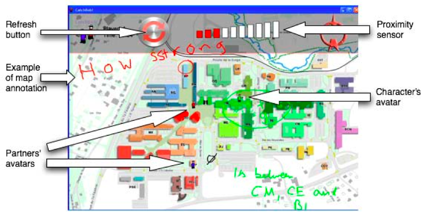
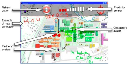
Location awareness is the knowledge of the position of one’s interaction partners both in physical environments and in virtual worlds. This information is extremely important for the coordination of communication and collaborative problem solving especially when participants are not nearby. Nova, in his PhD work conducted a series of timely experiments to demonstrate the impact of location awareness on collaborative work at a distance [Nova, 2007]. He designed an ubiquitous treasure-hunt game, called CatchBob! where three participants had to walk around a campus area to chase a virtual object. They had at their disposal a tablet PC running the interface represented in figure 1. Using this system, they could communicate with their partners annotating the campus map with the stylus of the tablet and have information on their proximity to the virtual object to be found. He compared experimental conditions where partners could see the position of their partners with a control condition where participants could see only their position. After the game, he interviewed the participant. In particular, he asked the participant to draw the recalled path of his/her partners, comparing this information with the real traces from the system logs.

figure 1. CatchBob! interface as seen by one player

Nova Catchbob

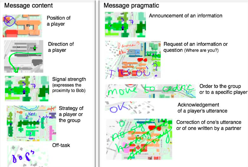
Using this experimental design, he demonstrated that the availability of what he called Mutual-Location Awareness tool (MLA) had an impact on collaboration. In particular, for the players knowing where the others were located both with automatic refresh of the information, or with manual refresh, had inhibiting effects on communication within groups and on the recall of partners’ past positions. It also made the group more passive than those who did not have this interface. Nova and colleagues also analyzed the messages exchanged during the game. He used the coding scheme reported in figure 2, where messages were classed by content and by pragmatic use. Consistently with the process measures described above, he found that players in the control condition exchanged more messages about position, direction and strategy that those with the synchronous MLA. They found also a negative correlation between the frequency of messages about strategy and the number of errors made by the individual when drawing their partner’s path [Nova et al., 2005].

figure 2. Example of messages exchanged by the CatchBob! players. Nova coded these messages using two intertwined coding scheme: message content and message pragmatics

Nova Coding-Scheme

These studies brought forward the various roles of mutual location-awareness ranging from a resource for division of labor to the facilitation of situation understanding or the use of past positions to draw hypotheses about the partners’ future behavior. Nova finally discussed how automating location-awareness can be detrimental to group collaboration in certain situations [Nova, 2007].

[1] Nova, N. The influence of location awareness on computer-supported collaboration. n. 3769, École Polytechnique Fédérale de Lausanne (EPFL), Lausanne, Switzerland, March 2007. [pdf]

[2] Nova, N., Girardin, F., and Dillenbourg, P. ’location is not enough! ’: an empirical study of location-awareness in mobile collaboration. In Proceeding of the third IEEE International Workshop on Wireless and Mobile Technologies in Educations (Tokushima, Japan, November 28-30 2005), IEEE Press, pp. 21–28. [pdf]

Mida’s touch problem of Eye-Gaze Interfacing

I came across this issue a couple of times and I decided to make a blog-post reminder for my personal glossary.

The “Mida’s Touch” problem refers to the fact that the eyes cannot be used directly as a mouse, because the eyes are never “off.” Thus one of the main problems when using the eye-gaze for selection purpose is to somehow combine it with a “clutch” that can engage/disengage eye-gaze control. A good clutch should be quick to operate, not increase the cognitive load unnecessarily and not disturb the user’s gaze-pattern, because the user will often be looking at some object when she wants to engage eye-tracking, and it would thus slow down the communication if she had to move her eyes to do it.

[More]

Commune: a shared drawing surface

Bly, S. A., and Minneman, S. L. Commune: a shared drawing surface. In Proceedings of the ACM SIGOIS and IEEE CS TC-OA conference on Office information systems (New York, NY, USA, 1990), ACM, pp. 184–192. [pdf]

————

The starting assumption of this work was that in group design situations, the activity of creating and using the marks on the drawing surface is as important as the marks themselves. During observations of design meetings, the authors identified three kinds of actions: draw, write and gesture. These were combined in different ways to support different uses: providing illustrations, or emphasis on a particular part of the talk, provide visual reminders, making references or other uses.

To support these mechanisms at a distance the authors designed a system called Commune where users could superimpose sketches to a common drawing surface while talking. They conducted a tight observation of use of the system by several pairs and they found that neither the talk nor the marks alone effectively communicate the issue under consideration.

One of the advantage that they saw in the use of Commune was the ability to be in the same place at the same time. While this is possible with the virtual superimosition of the marks that is not actually possible in real situations and the authors speculated that this could have been an advantage.

However, they also identified three problems: the stilii were difficult to use with sketches consisting of short line segments; second the drawing space was small and finally Commune constrained gestures to pointing actions.

Bly Commune

Bly Commune Sketch-Talk