
The main idea contained in this paper is that CSCL lacks of tools for representing the interactions as this is considered to be fundamental for understanding the collaborative learning. For the author, the proposed solution, in XML, may support the evaluation of the collaborative learning. For me, it also add an important dimension to the support of the learning process per se. Finally, this paper contains the definition of what is a Collaborative Action: “An action that by itself or by its effects can be perceived by at least a member of the group distinct of the one that performed the action.”
Author: Mauro Cherubini
Action-Driven Ontologies of the Geographical Space
This paper, like per Kuhn’s one (\ref{Kuhn01}), aim at adding more dimension to ontologies of geographical kinds. The aim is to make these tools more aware of the user’s side, considering the dynamical character of geographical entities and the intentionality dimensions of the geographical space. The former aim at thinking about the usage of the data stored into the system, particularly at the representation in which those will be used. The latter add a different perspective to the geographical objects considering their evanescence embedded in their nature.
Visualising Conversation
————————
This article provides a pioneer point of view on the research fro building visual representation of textual conversation in such a way to prevent the amassment of information. The idea is to use ChatCircles, a visual display that render the age of a message as a circle whose radios shrink with the passing time. The goal of this research is to provide to textual communication a background able to convey some social aspect of the communication like the turn taking ecc. In addition there is also the idea of archiving the conversations in such a way to convey some of those meanings.
Ontologies in support of human activities in geographical space
W. Kuhn. Ontologies in support of activities in geographical space. International Journal of activities in geographical space, 15(7):613–631, 2001.
——————————
The climax of this paper is that information system ontologies contain a view of the world that has less to do with human activities than with data holdings. The paper postulates that in order to make geographical information more useful and usable, ontologies should be designed with a focus on human activities. The author suggests that the entities admitted in the ontology should be defined by the task or activities supported in the GIS. The second step, which the author calls grounding, is the process of selecting which activities are are relevant to the user in a particular domain. Simplifying the steps of the method: a) selection or production of natural language text describing activities in a domain; b) extraction of the actions from the verbs of the text; c) Identification of the object classes affording these actions from the nouns; d) Ordering of these actions according to entailment relations among the verbs; e) production of the action hierarchy. In conclusion, this paper presents a well formed bibliography in the field of ontologies in supports of activities in geographical space.
SVG Mobile in a commercial context
…
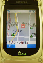
Commercial services using SVG Tiny are already in use on cellphones in Japan; other countries are expected to see such services shortly.
For example, here are some shots of a real Mobile Commerce application developed by KDDI Corp., – a major Japanese cellular phone carrier and member of the SVG Working Group – in partnership with JCB Co., Ltd., Toyota Finance Corp., Mitsui Sumitomo Card Co., Ltd., and UC Card Co., Ltd. It is using the SVG Tiny implementation from KDDI running on the KDDI “au” 3rd-generation CDMA20001x phones which have color screens. The customer is being shown an SVG map of the nearest participating store; in the next screen, zooming on the map reveals more details of how to get to the store, including smaller streets not visible on the larger view; in the last shot, the opening hours and contact details of the store are displayed in SVG as the customer walks towards the store to make a purchase just before closing time.
…
[more…]
EWall
EWall is an interactive installation that enables the concept of inhabitable interfaces. Basically a building is transformed to a maze display which can be used for collaboration over distance or in presence:
EWall proposes a computational solution to help problem solvers work faster and produce smarter solutions through easily collecting, organizing and viewing graphical and contextual information. It will also facilitate user collaboration in large, distributed and decentralized teams while maintaining individual ways of working.
An interesting concept was the idea of building an EWall Operating System for the personalization of the kind of interaction with the wall:

Interactive Systems for Knowledge Sharing
TITLE OF PAPER: Designing Interactive Systems for Knowledge Sharing
PRESENTED BY: Jeffrey Huang, Design School, Harvard University
DATE: July, 15, 2004
LOCATION: I&C
—
REAL-TIME NOTES:
Nowadays, it is not possible for a single person to have all the knoledge necessary for buyilding a skyscreaper. So there is a trend from Masterbuildres to Design Teams. There are lots of problems of knowledge sharing: the more distance there are between the specialists, the tranfer of knowledge cost.
The 3 dimensions over which this work develop is a) to reduce the costs of knowledge transfer, like making it more trnsparent; b) reducing the agency costs to make results more transparent; c) making the specialist and the architect closer (collocate participants virtually).
The background of this research is as follows:
– Design of Online Communities (Activity patterns, …) -> Eventspace [Urs Hirschberg]
– Visualising interaction history (visualise abstract data) [Eva Papadimitriou, 2002]
– Situational Instant Messaging System !!!!
– Physical Communication Interface [Surapong Lerthisichai, 1999-2003]
The focus of this presentation is on how to solve the bottleneck effect of the joint of the virtual system over the physical one. The approach is to turn the whole building as an interface. [Information Visualization, CSCW, Ubiquitous Computing] -> Mediaspace
A napkin idea!
Concept of “inhabitalbe interface”: the bought a building in cambridge as a testbed they installed lots of IT in it. Walls were transformed in displays so that a research could be projected on the walls for the viewer to navigate physically. Other functionalities could help the visitor to arrange for a meeting in which two walls coud be used for projecting distance places or people far away.
Later on the house was connceted with the Swiss embassy and with the EPF-Z.
An interesting point is the attempt to create a software to merge all sorts of different media to interoperate withe these e-walls: EWall Operating System [1]:
– Cards are handles for knowledge (containers of informations\
-Algorithms for detecting how people arrange cards
– Algorithms for analysing and extracting facts from interaction history
Flows:
1. User create cards
2. EWalls formulates probable relations amonng the cards
3. …
Principles:
1. Adaptation to rather than imposition of human work process
2. Interpretation of user activities through observation tather than user responses
3. Focus on ispiring rather than directing
4. Focus on context rather than content of information
5. Focus on modular rather than integrated solution
–
Things to check:
– swisshouse: nodes of the swiss embassy around the world
– ewall[1]
—
REFERENCES: {as documents / sites are referenced add them below}
[1] http://ewall.mit.edu/abstract/index.html/
…
—
Leaving Kibbutz
Sad but true: the kibbutz community is over. The ages of pasta and vinegar will remain forever and will become legend.

digital street game
Digital street game seems to reflect the philosophy initially behind MapTribe:
By using a game as an open-ended platform for research we hope to encourage creative expression and collaborative play. As part of the game, players generate documentation and commentary that traces their paths through the game – and the city. Different views of these traces create a prismatic portrait of urban places as mediated through technology use and social relationships. The game becomes a methodological experiment in producing a rich environment for community engagement and social research.

Meeting with Enrico Franconi
There is a competition on building categorization on the fly which is called TRECK? Natural Language Processing.
Some good approaches to my particular field are the Cataloging provided by Ontologies, but this is not enough because ontologies do a very precise thing and they do it very precisely, on the other side we want to have a very specific solution which accomplish a very definite task.
The other theoretical field to look at is the Spatial Reasoning, particularly in the field of AI. On the the examples may be provided by the Discourse Rhetorical Theory (DRT) [Ludwig, 2000]. Also, Brendan Bennet, University of Leeds.
Also the text categorization as per Moore and Paris.
Another extra piece of work to look at is the Question Answering, particularly the work of Maarten de Reijke.
Concerning the Ontologies, probably the best approach is to look at Formal Ontologies which mix psychological, logical and philosophical approaches. Two researchers to look at may be Berry Smith and Cristiano Castelfranchi.
A possible procedure that I should try to put in place for the thesis’ work is to define a psichological model, then translate this model into a logical description and finally translate this into a software implementation. After this it is possible to run the “Prova di Completezza”, which verifies if the algorithm is actually responding to the logical method. Logic is based on semantics therefore a model can be validated from the right semantic implications (meaning).